Core Capture Services & 3D Tour Production Services
What we do: We extract exact spatial data and build commercial visual assets. This covers 3D virtual tours, LiDAR scanning, and aerial drone surveys.
Who we help: We work directly with commercial estate agents, event space owners, architects, facilities managers, and premium hospitality owners.
Where we operate: Our main office is in Sheffield and work across major UK commercial centres and throughout France to capture premium assets.
How we work: We don’t try to make one camera do everything. We own and operate a specific fleet of commercial-grade 3D cameras, LiDAR scanners, drones, and DSLR cameras. We simply match the exact tool to your environment to guarantee accurate results.
Why you need this: Our services massively improve your marketing activities in hospitality, reduce wasted visits in real estate, and gives you reliable structural data for architectural, engineering and construction companies.
When to use us: We support marketing activities in hospitality, facilities renovation, help track progress during construction work, and help launch a property to global buyers.
1. High-Precision 3D Digital Twins & Virtual Tours
What it is: Creating immersive, millimeter-accurate 3D replicas of physical environments that users can walk through remotely.
How it is delivered: Using the Matterport Pro3 for vast commercial/outdoor properties, the Matterport Pro2 for stunning high-fidelity indoor spaces, and the Insta360 X5 for rapid, continuous walkthroughs.
2. High-Density LiDAR Scanning & Spatial Data Extraction
What it is: Capturing millions of data points to map structural layouts and complex geometry with absolute measurement certainty.
How it is delivered: Utilizing the 3DMakerPro Eagle Max with its integrated RTK module for large-scale industrial complexes and outdoor sites requiring global satellite coordinate alignment, alongside the Matterport Pro3 for structural data.
What it is: Capturing sweeping, high-resolution overhead views and stable exterior video of large estates, venues, and developments.
How it is delivered: Deploying the DJI Air 3S commercial drone, leveraging its dual-lens system (wide-angle and 70mm telephoto) and forward-facing LiDAR to safely capture stunning aerial assets.
4. Premium Architectural & Commercial Photography
What it is: Producing ultra-high-resolution, print-ready still imagery that highlights lighting, material textures, and architectural finishes.
How it is delivered: Using the full-frame Canon EOS 6D Mark II, capturing massive 26.2-megapixel files tailored for web platforms, corporate branding, and large-format business signage.
B2B Applications & Deliverables
You can package this hardware suite to target specific professional workflows:
As-Built Documentation & BIM Assets: Generating precise point clouds, OBJ files, and structural data to export directly into CAD/BIM software for architects, engineers, and construction managers.
High-End Hospitality & Event Space Marketing: Providing premium virtual walkthroughs and cinematic aerial overviews of country houses, wedding venues, and corporate spaces to drive bookings and eliminate wasted physical viewings.
Industrial Facility Auditing & Safety Training: Scanning factory floors, plant rooms, and manufacturing plants to map asset locations, plan machinery installations, and build immersive, 360-degree virtual safety briefings for incoming staff.
Construction Progress Tracking: Performing rapid, continuous site walks (via the hard-hat-mounted Insta360 X5) or aerial sweeps to give project managers and stakeholders an indisputable, weekly visual timeline of a build’s progress.
Asset Management & Insurance Documentation: Delivering a complete, accurate, and timestamped photographic and spatial record of retail or commercial properties for underwriting or rapid claims processing.
Elevated Structural Auditing: Inspecting hard-to-reach physical structures—such as high-level brickwork, roofs, and chimneys—using the DJI Air 3S drone, avoiding the immediate setup cost and hazard of scaffolding or ladders.
1. High-End Hospitality & Premium Event Spaces
This sector uses your services to drive digital bookings, showcase luxury venues, and filter out casual, non-buying viewings.
The Customers: Boutique hotel owners, country house estate managers, wedding venue operators, luxury retreat directors, and corporate event space managers.
How they use you: Immersive Matterport Pro2 indoor tours to show room layouts, DJI Air 3S aerial films to showcase the grounds, and Canon 6D Mark II stills for high-end print brochures.
2. Commercial Real Estate & Retail
These businesses need to market large offices, industrial units, or retail layouts to international tenants and buyers without arranging constant physical site visits.
The Customers: Commercial estate agents, retail asset managers, property investors, and corporate office developers.
How they use you:Matterport Pro3 walkthroughs of massive warehouses, interactive virtual storefronts for retail brands, and high-resolution full-frame photography for premium property listings.
3. Architecture, Engineering, & Construction (AEC)
This sector requires raw, precise spatial data to plan renovations, track build progress, and verify that structures match schematic designs.
The Customers: Architects, main construction contractors, civil engineers, project managers, and BIM (Building Information Modelling) coordinators.
How they use you:3DMakerPro Eagle Max RTK scans for millimeter-accurate point clouds of structural frameworks, and weekly hard-hat-mounted Insta360 X5 walks to track construction progress for off-site stakeholders.
4. Industrial Facilities & Manufacturing
Heavy industry relies on visual data to improve operational efficiency, plan new factory layouts, and train staff safely in high-risk environments.
The Customers: Factory managers, plant operations directors, industrial asset auditors, and health and safety officers.
How they use you: Comprehensive 3D digital twins of processing plants to map machine placements, and 360-degree virtual safety briefings to train incoming contractors before they enter live production areas.
5. Facilities Management & Property Maintenance
Large-scale property managers use digital data to inspect high-level assets safely and manage complex building portfolios from their desks.
The Customers: Facilities managers, corporate landlords, university estate directors, and building surveyors.
How they use you:DJI Air 3S aerial inspections to check roof tiles and chimneys without paying for scaffolding, and Matterport Pro3 scans to log utility points, boilers, and plant rooms across multiple buildings.
6. Business Signage & Branding Agencies
This niche requires ultra-high-resolution, perfectly sharp imagery to design and produce physical corporate graphics.
The Customers: Signage production managers, graphic designers, corporate marketing directors, and shopfitters.
How they use you: Large-format Canon 6D Mark II photography to ensure print graphics for storefronts, vehicle wraps, and business signage remain perfectly crisp when scaled up to massive sizes.
Immersive 3D Virtual Tours: London, Paris, Nice, and Throughout France
We create high-precision 3D virtual tours and digital twins that allow prospective clients to inspect, navigate, and experience your premium spaces from anywhere in the world. By combining long-range LiDAR scanning with high-fidelity visual capture, we turn physical architecture into immersive, millimetre-accurate online walkthroughs that drive direct bookings and eliminate wasted viewings.
While our technical infrastructure is based in Sheffield, our primary deployment for luxury hospitality and premium corporate spaces focuses on London and the key markets across France, including Paris and the French Riviera.
London & the UK Corporate Hub
In London, we deploy our advanced scanning hardware to support high-end real estate, corporate offices, and premium retail showrooms. We deliver elite digital assets that give international investors, corporate tenants, and high-net-worth clients immediate, trusted visual access to commercial portfolios without the need for travel.
Paris, Nice, & Nationwide France
We specialise in the international hospitality and event sector across France. Operating extensively from Paris to Nice, Cannes, and the broader Côte d’Azur, we capture luxury chateaus, boutique hotels, and premium event venues. Our high-fidelity tours give French property owners a powerful digital asset to secure high-value bookings from UK, US, and global clients who demand an authentic, transparent view of a property before committing.
Whether you manage a corporate asset in the heart of London, a premium event space in Paris, or a luxury coastal estate in Nice, we provide the exact hardware and expertise required to replicate your physical space with absolute certainty.
South Yorkshire (Our Operational Base)
We are based in Sheffield. This serves as our central hub for rapid deployment across the region. We provide fast, cost-effective digital capture services without charging heavy travel fees.
Sheffield: We cover the entire city. We focus heavily on commercial real estate, industrial units, and corporate event venues.
Rotherham and Doncaster: We capture the massive logistical hubs, factory spaces, and commercial developments running along the M1 and A1 corridors.
Barnsley: We provide architectural scanning and digital walkthroughs for local development projects and hospitality venues.
Derbyshire and the Peak District
This region holds a dense concentration of premium rural venues, heritage sites, and commercial infrastructure. We deploy here regularly to capture both outdoor landscapes and complex indoor spaces.
Chesterfield and Derby: We provide industrial scanning, commercial photography, and virtual tours for corporate properties and manufacturing facilities.
Matlock, Buxton, and Bakewell: We capture premium country houses, rural event spaces, and boutique hotels. Our aerial drone services and Matterport tours work perfectly to showcase these luxury Peak District venues to distant buyers and guests.
Major UK Commercial Centres
We travel to the UK’s primary corporate hubs to document large-scale architectural projects, premium retail spaces, and corporate assets.
Manchester: We provide regular LiDAR scanning and digital twin services across Greater Manchester. This supports the heavy concentration of commercial property developers, architects, and industrial asset managers in the North West.
London: We deploy to the capital for high-end corporate capture. We handle luxury hospitality virtual tours, premium retail documentation, and large construction progress tracking across the city.
France (International Hospitality)
We operate across France to service the premium hospitality and event sector. We use our Go Casa digital lens to market these exact spaces to an international audience.
Luxury Venues: We capture chateaus, boutique hotels, and high-end holiday rentals across the country.
Remote Digital Marketing: We build high-fidelity 3D virtual tours and capture cinematic aerial footage. This helps French property owners secure direct bookings from UK and US clients who cannot attend a physical viewing.
Our Kit list – Scanners, Cameras, and Drones
The following section outlines the different cameras, scanners, and drones we use on our projects. Different environments require different types of data, so we don’t try to force one piece of kit to do everything. We simply match the exact tool to your requirements. This ensures you get highly accurate results, whether you need raw structural measurements of a factory floor or a premium virtual tour of a venue.
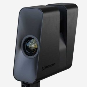
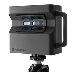
Matterport Pro3 LiDAR Camera
We use the Matterport Pro3 to create high-precision 3D tours, 3D digital twins and schematic floor plans of commercial properties, hospitality spaces, and construction sites. This system combines long-range LiDAR scanning with high-resolution imagery to replicate physical spaces online.
Technical Highlights
The Pro3 delivers fast, accurate spatial capture across large indoor areas and outdoor environments.
100-Metre LiDAR Range: The laser sensor captures structural data up to 100 metres away. This allows us to map massive spaces quickly.
Outdoor Capability: Unlike older systems, the Pro3 works flawlessly in direct sunlight. This ensures complete continuity when mapping external spaces, loading bays, and grounds.
20-Megapixel Sensor: The camera captures crisp, clear visual data. This guarantees that text on safety signs, equipment labels, and architectural details remains perfectly legible.
High-Speed Sweeps: Each 360-degree scan takes less than 20 seconds. This minimises disruption to your daily operations during a site visit.
What We Use It For
We deploy the Pro3 to build interactive, walk-through digital twins. This tool goes beyond simple visual photography. It calculates the exact measurements of a room and generates assets like OBJ files, point clouds, and BIM-ready data. We use this to help you manage assets, market premium spaces, and audit physical environments without stepping foot on site.
Core Applications
The Pro3 serves multiple commercial and industrial purposes.
Property Marketing: We generate high-end virtual tours for hospitality venues and corporate event spaces to secure bookings and reduce wasted viewings.
Construction Progress Tracking: We document building stages to provide project managers and stakeholders with clear, measurable proof of work.
Facilities Management: We map corporate offices and industrial assets to give maintenance teams remote access to structural layouts and utility locations.
Who Benefits From This Service
This service helps businesses streamline their remote operations and marketing. Our typical clients include commercial estate agents, hospitality managers, facility operators, and construction contractors. The Pro3 delivers a perfect balance of visual detail and structural accuracy to save you time and travel expenses.
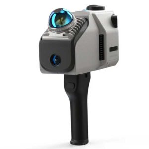
3DMakerPro Eagle Max LiDAR Scanner
We use the 3DMakerPro Eagle Max to capture large industrial spaces and complex buildings with absolute precision. This handheld LiDAR scanner maps your physical environment and converts it into a highly accurate 3D digital model.
Technical Highlights
The Eagle Max is the top tier configuration of this scanning system. It captures heavy duty spatial data, and it doesn’t require traditional setup time.
140 Metre Range: The LiDAR engine scans objects up to 140 metres away. And it maintains a 2 centimetre accuracy at a 10 metre distance.
Rapid Data Capture: It records 200,000 data points every second. This helps to map massive buildings and outdoor compounds in minutes instead of days.
8K Colour Imaging: The Max variant features four 48 megapixel cameras. This guarantees the final 3D point cloud is rendered in full, accurate colour.
Integrated RTK Module: Real Time Kinematic positioning locks the scanner to global satellite data. This ensures your final 3D model aligns perfectly with real world geographical coordinates.
What We Use It For
We deploy the Eagle Max when standard photography falls short. It extracts raw spatial data from complex environments. We use this data to generate highly accurate 3D floor plans, topographical maps, and immersive digital twins. The four built in cameras let us output full colour point clouds. This helps you inspect the exact visual condition of a site alongside its structural dimensions.
Core Applications
This scanner performs exceptionally well across both indoor and outdoor environments.
Industrial Auditing: We scan factory floors and processing plants to help you plan new machinery layouts or conduct safety training.
Architectural Surveying: We capture building facades and complex interior layouts to give architects exact measurements for renovation work.
Facility Management: We build comprehensive digital twins of your real estate. This means your maintenance teams can inspect properties remotely.
Who Benefits From This Service
This tool serves professionals who require absolute measurement certainty. Our typical customers include commercial property developers, architects, health and safety auditors, and factory operators. If you manage a large facility, this service prevents wasted site visits. It gives you a perfect 3D replica of your property to work with directly from your desk.
DJI Air 3S Commercial Drone
We use the DJI Air 3S drone to capture high-resolution aerial imagery and detailed exterior video of commercial properties, hospitality venues, and development sites. This advanced aircraft provides the perfect balance of portability, flight safety, and dual-lens camera capability to deliver comprehensive spatial context from above.
Technical Highlights
The Air 3S features a high-performance dual-camera system and advanced environmental sensing to operate safely close to complex structures.
Dual-Camera System: The main camera features a large 1-inch 50-megapixel sensor for wide property shots. The secondary camera provides a 70mm medium telephoto lens with a 48-megapixel sensor to capture close-up details without flying closer to the building.
Forward-Facing LiDAR: Built-in LiDAR scanning handles forward obstacle detection. This works alongside omnidirectional night-sensing technology to prevent collisions with trees, cables, or structural walls.
45-Minute Flight Time: The extended battery life allows us to map entire estates and large commercial properties on a single flight. This keeps our time on site short and efficient.
O4 HD Video Transmission: This advanced system maintains a rock-solid, ultra-high-definition video link up to several kilometres away. This ensures steady, uninterrupted data capture in areas with heavy wireless interference.
What We Use It For
We deploy the Air 3S when standard ground-based photography cannot capture the full scale of a property. It delivers dramatic exterior overheads and detailed close-ups of elevated structures. We use this aerial visual data to create promotional property films, assess roof conditions, and provide geographic context for large developments or rural event spaces.
Core Applications
The Air 3S is highly effective for visual marketing and asset inspection.
Hospitality and Venue Marketing: We capture sweeping aerial footage of premium country houses, golf courses, and outdoor event spaces to give prospective clients an immediate sense of scale and luxury.
Commercial Property Promotion: We provide clear overhead views of industrial estates, business parks, and retail outlets to help agents attract corporate tenants or buyers.
Elevated Visual Auditing: We inspect high-level structural assets, chimneys, and roof tiles safely from the air. This removes the immediate need for expensive scaffolding or ladders just to check an asset’s condition.
Who Benefits From This Service
This aerial capture service serves estate agents, hospitality business owners, and commercial property managers. If you need to showcase a large venue to drive bookings, or if you require an efficient, safe method to inspect the exterior condition of your building, the Air 3S delivers professional results without the massive footprint of heavy industrial aircraft.
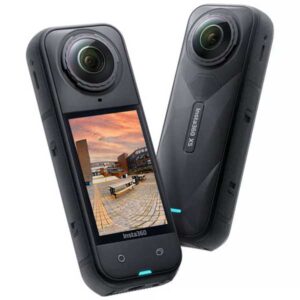
Insta360 X5 8K 360 Camera
We use the Insta360 X5 to capture rapid 360-degree visual documentation in dynamic environments. This compact camera records everything in an 8K spherical view. This helps us document active sites quickly without stopping to frame individual shots.
Technical Highlights
The X5 is built for speed and mobility in difficult environments. It provides high-resolution capture without the setup time of a static scanner.
8K 360-Degree Video: The dual 1/1.28-inch sensors capture massive spherical video files. This guarantees crisp, detailed footage even when you zoom in on specific areas during a digital review.
Triple AI Architecture: The camera features dedicated processing chips to actively reduce visual noise. This helps to capture clear, bright footage inside poorly lit industrial spaces or basements.
Extended Battery Life: It records for up to 185 minutes on a single charge. And this means we can document massive construction sites or large factory floors without stopping to swap batteries.
Rugged Build: The camera is waterproof up to 15 metres and features replaceable ultra-hard lenses. This allows us to work in harsh environments or active construction zones safely.
What We Use It For
We deploy the X5 when speed and mobility are the main priorities. It integrates directly with spatial mapping software to create rapid digital walkthroughs. We mount it to a hard hat or a handheld pole to record continuous 360-degree video as we walk through a site. The software then processes this footage into an interactive map of your facility.
Core Applications
The X5 serves as the perfect tool for fast, regular site documentation.
Construction Progress Tracking: We walk your active site weekly to record the build progress. This gives project managers a complete visual timeline to compare against schematic plans.
Confined Space Auditing: We use this compact camera to document tight spaces, plant rooms, and ceiling voids where our larger LiDAR scanners cannot fit.
Health and Safety Briefings: We capture immersive 360-degree video of active factory floors. You use this to train staff on specific site hazards before they step into the industrial environment.
Who Benefits From This Service
This rapid capture service works best for project managers, health and safety officers, and construction contractors. If you need a fast, affordable way to track site progress or document hazardous environments, the X5 delivers the exact visual data you require without the time investment of heavy LiDAR scanning.
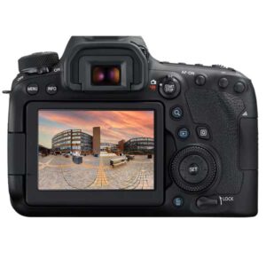
Canon EOS 6D Mark II DSLR Camera
We use the Canon EOS 6D Mark II to capture high-resolution, professional-grade still photography for commercial properties, corporate marketing, and high-end business signage. This full-frame camera platform provides exceptional detail, color accuracy, and low-light performance.
Technical Highlights
The 6D Mark II delivers crisp, ultra-detailed visual assets that look perfectly sharp on digital screens and physical print.
26.2-Megapixel Full-Frame Sensor: This captures massive image files with incredible clarity. This ensures your photography remains perfectly crisp, even when blown up for large-format corporate signage or banners.
Dual Pixel CMOS Autofocus: This system locks focus instantly on architectural details, interior elements, or industrial machinery. It ensures every shot is sharp from edge to edge.
Vari-Angle Touchscreen: The articulating screen allows us to frame difficult low-angle or overhead shots with high precision. This helps us document cramped interior layouts or complex factory plant rooms.
Built-In GPS Geo-Tagging: The camera automatically embeds exact location coordinates into the metadata of every image file. This works brilliantly for cataloging massive industrial sites or tracking multi-property portfolios.
What We Use It For
We deploy the 6D Mark II when your marketing or documentation demands the absolute highest level of photographic detail and colour fidelity. It serves as our primary tool for high-end architectural stills, interior design showcases, and raw image assets destined for web development, branding materials, or physical print.
Core Applications
This full-frame camera handles a wide variety of commercial imaging needs.
High-End Architectural Photography: We capture detailed interior and exterior images that highlight the texture, lighting, and premium finishes of your hospitality or event spaces.
Corporate and Industrial Asset Capture: We shoot sharp, professional imagery of your facilities and machinery in action. This provides authentic visual content to populate your digital infrastructure.
Signage and Large-Format Print: The high sensor resolution provides the necessary pixel density to print sharp, professional graphics for storefronts, business signage, and corporate displays.
Who Benefits From This Service
This service helps commercial property owners, marketing directors, and retail businesses who need premium visual content to drive enquiries and bookings. The 6D Mark II ensures your physical premises look as polished, grounded, and professional in print or online as they do in person.
Matterport Pro2 3D Camera
We use the Matterport Pro2 to create high-resolution 3D virtual tours and detailed schematic floor plans for indoor properties. This camera represents the industry standard for high-fidelity visual marketing and internal documentation of residential, commercial, and retail spaces.
Technical Highlights
The Pro2 uses a combination of high-definition lenses and infrared sensors to map interior environments quickly and reliably.
134-Megapixel Imagery: The camera captures ultra-high-resolution panoramic images. This ensures every detail of an interior space is perfectly sharp, from small text on signs to fine material textures.
Infrared Depth Mapping: Structured light sensors measure indoor spaces with 99% accuracy. This allows us to extract precise dimensions and generate reliable floor plans.
Rapid Capture Cycle: The camera rotates automatically to complete a full 360-degree scan in seconds. This speed minimises disruption to your daily operations during our site visit.
High-Fidelity 3D Dollhouses: The system stitches separate scans together to create an interactive 3D model of the building. This lets users understand the complete layout of a property at a glance.
What We Use It For
We deploy the Pro2 for indoor environments where exceptional visual quality is just as important as structural layout. It captures precise physical dimensions while delivering vibrant, professional-grade photography. We use this data to generate interactive digital walkthroughs, architectural floor plans, and complete photographic records of indoor assets.
Core Applications
The Pro2 performs exceptionally well across a wide range of commercial and residential indoor sectors.
Commercial and Residential Real Estate: We create immersive walkthroughs for property listings. This helps buyers inspect homes or offices from anywhere in the world and filters out casual viewers.
Retail and Showroom Tours: We build virtual storefronts that let customers browse your physical retail layout online. You can link these directly to your e-commerce platform to drive digital sales.
Insurance and Asset Documentation: We capture a complete, indisputable visual record of indoor property conditions. This helps asset managers and insurers speed up claims and simplify underwriting.
Who Benefits From This Service
This service helps estate agents, retail managers, and property investors who need to showcase interior spaces with premium visuals. The Pro2 provides a proven, cost-effective route to boost online engagement, increase property enquiries, and document assets without the higher cost of long-range outdoor LiDAR scanning.
Book your 3D tour, photography, capture services, or LiDAR scan